Mapping Household Income and Lifestyle Choices in Switzerland: A Geospatial and Cluster-Based Analysis Using Swiss Household Panel Data

Context
Understanding how people spend their income is vital for businesses, urban planners, and policymakers alike. In Switzerland, where economic and cultural diversity is pronounced even at the municipality level, traditional canton-level analyses fail to capture important nuances. While affluent areas may lean towards organic food and premium leisure, others prioritize affordability and access. The need for micro-regional insights has become increasingly important for location-based decision making.
Goal and Tasks
This thesis investigates how household income relates to lifestyle choices in Switzerland and whether these patterns differ significantly between municipalities. The primary goal was to bridge a research gap by producing an interactive, spatially differentiated map that visualizes lifestyle segments derived from the Swiss Household Panel (SHP) data. The main tasks included:
- Analyzing SHP data to detect income-related consumption behaviors
- Identifying lifestyle clusters using statistical models
- Mapping these patterns to Swiss municipalities to guide business and policy strategy
Methods
Following the Design Science Research methodology, this thesis focused on artifact creation and evaluation. Cluster analysis and predictive modeling were applied to a cleaned SHP dataset. Using municipality level BFS identifiers, results were visualized in an interactive map, enabling users to explore regional variations in consumption and lifestyle choices. Techniques from data science and geospatial analytics were combined to ensure both rigor and relevance.
Results
The results confirm a strong link between income and lifestyle. Higher income municipalities favor health conscious and luxury consumption, while lower income areas prioritize price sensitive behavior. Surprisingly, lifestyle diversity exists even within the same canton, revealing previously overlooked micro-regional differences. The resulting map is not just a visualization but a strategic tool that offers actionable insights for businesses exploring location based expansion, and for policymakers aiming for targeted service distribution.
The maps below illustrate the evolution of lifestyle segmentation in Switzerland across two analytical iterations.
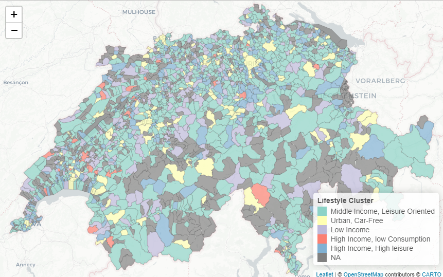
The first map represents the initial clustering outcome based on key income and lifestyle variables from the Swiss Household Panel (SHP). While this version highlights broad lifestyle trends, its granularity and interpretability were limited.
The second map reflects an improved model developed through refined variable selection and clustering techniques. This iteration offers greater accuracy, clearer regional distinctions, and more actionable segmentation for business and policy decisions.
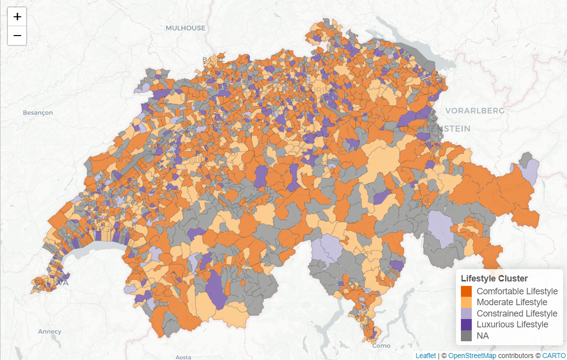
Together, the two maps showcase how iterative data modeling enhances spatial insights and helps reveal the nuanced relationship between household income and lifestyle choices at the municipal level.